|
|
The project involved invited distinguished researchers from abroad, who contributed with their expertise. The transfer of know-how, which took place through meetings and seminars, was a key factor in the innovative nature of the project. |

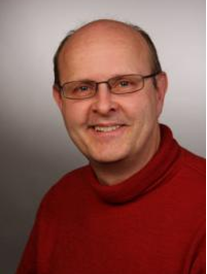 |
Dr. Steffen Kuntz has more than 20 years of experience in remote sensing and GIS. Working since 1993 in industry his activities included for instance product marketing and project management in Europe, the Near East, South America and Indonesia. Since 2002 he is employed by Infoterra GmbH as senior advisor for geo-information systems and climate change programs (Kyoto Protocol, REDD+, etc). Since 1997 he was Assistant Professor for remote sensing and GIS at the University of Freiburg, Faculty for Forestry and Natural Resources Management. His teaching activities comprise introductory courses in remote sensing and GIS, sampling statistics and ground truth assessment. He gave MSc courses in the Univ. Thessaloniki, MAICh, and at the University of Münster. Since 2005 he is Honourable Professor at the Univ. of Freiburg, Faculty for Forestry and Environmental Science for Remote Sensing and Geographic Information Systems. |
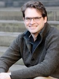 |
Dr. Iain Woodhouse is interested in active remote sensing of forests using physical models, rather than statistical models or classification with the aim of sustaining forests worldwide, with a focus to Africa. This included the first linking of a plant structure model from macroecology with radar simulation models. In the UK, his research focuses on new instruments for forest mapping developed by his own team, highlighted by ESA as "very innovative mission concept". In Africa, he is leading the REDD Horizon project in Malawi. This followed on from my Scotland-Malawi Partnership Academic Fellowship that he undertook during sabbatical in 2007. This research aims to establish the best methods of monitoring forest and their carbon content, combining satellite data and community level measurements. It is within the context of ongoing continental scale mapping of African forests using satellites, which Edinburgh is now developing internationally recognised expertise (with Williams, Ryan, Mitchard, Grace). He is currently a Lecturer in Earth Observation (SL from 2006), University of Edinburgh, UK. |

")
-
February 17th, 2015 – Research group meetingThe research groups met and discussed the hitherto progress of the project, and the next steps that will lead to the successful project completion.
-
July 25th, 2014 – Article publishingPart of the project’s results were published in the article "Decision Fusion Based on Hyperspectral and Multispectral Satellite Imagery for Accurate Forest Species Mapping" in the Remote Sensing...
-
March 31st, 2014 - Article publishingPart of the project’s results were published in the article"Mediterranean forest species mapping using classification of Hyperion imagery" in the Geocarto International journal...
-
February 20th, 2014 - Article publishingPart of the project’s results were published in the article "A Comparative Analysis of EO-1 Hyperion, Quickbird and Landsat TM Imagery for Fuel Type Mapping of a Typical Mediterranean Landscape" in...
-
December 11th, 2013 – WorkshopAs part of the project, FMRS organized a workshop called 'Active Earth Observation', with both theoretical and practical parts. The training was held in English by Prof. Dr. Iain Woodhouse(University...
- More news