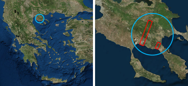
 The study area is located in central Chalkidiki and consists of two rectangle areas. The northern area is an area of 112 807 sq. Km., defined by the coordinates (23.4306 ° E, 40.2697 ° N) and (23.5883 ° E, 40.4817 ° N) and extends between the wooded areas of Arnea and the coast of Gerakini. The southern area is an area of 21 846 sq. Km., defined by the coordinates (23,6235 ° E, 40,2330 ° N) and (23,6911 ° E, 40,27717 ° N), and extends between the west part of the village of St. Nicholas and the west coast of Nikiti.
The land cover of the study area includes coniferous, broadleaved and mixed forests, as well as shrubs and grasslands with sclerophyllous vegetation, permanent crops (mainly olive trees and Christmas trees), arable land and crop complexes, mining sites and urban areas. The main forest species of the area are the Italian oak, beech, black pine, Turkish pine and aleppo pine. The fauna of the area is rich, with wild boar and game birds being among the most significant species.Part of the study area belongs to the Natura 2000 network of protected areas, as well as to the Regional National Park of Koronia-Volvi.
For further information for the study area please refer to Report 2.b

")
-
February 17th, 2015 – Research group meetingThe research groups met and discussed the hitherto progress of the project, and the next steps that will lead to the successful project completion.
-
July 25th, 2014 – Article publishingPart of the project’s results were published in the article "Decision Fusion Based on Hyperspectral and Multispectral Satellite Imagery for Accurate Forest Species Mapping" in the Remote Sensing...
-
March 31st, 2014 - Article publishingPart of the project’s results were published in the article"Mediterranean forest species mapping using classification of Hyperion imagery" in the Geocarto International journal...
-
February 20th, 2014 - Article publishingPart of the project’s results were published in the article "A Comparative Analysis of EO-1 Hyperion, Quickbird and Landsat TM Imagery for Fuel Type Mapping of a Typical Mediterranean Landscape" in...
-
December 11th, 2013 – WorkshopAs part of the project, FMRS organized a workshop called 'Active Earth Observation', with both theoretical and practical parts. The training was held in English by Prof. Dr. Iain Woodhouse(University...
- More news